Sliding Sands Trail Hike to the Haleakala Crater, Maui

So, there we were, fresh and early in the morning, after sunrise, on our way to the summit of Haleakala. Its a couple of hours drive from Lahaina in West Maui to the top of Haleakala. It was a bright sunny day, and we were looking forward to the adventure of hiking in the Haleakala crater.
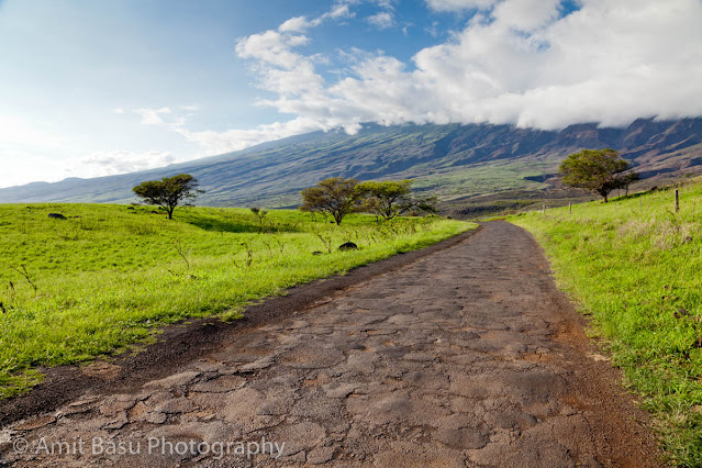
We got on to the Haleakala highway and then on to Crater Road near Kula, where the road starts to climb up the mountain, and slowly gets windy. It was bright green at places, and we could see the slopes of Haleakala at a distance. It was amazing how flat the top of the mountain looked.

Somewhere above 5000 feet or so, we started seeing bicyclists coming down the slope, led and trailed by pilot cars. Looked like fun. At 7000 odd feet, we entered the Haleakala National Park, and had our first sight of the elusive bird Nene. I remember we had searched in vain for Nene in our travels in the Big Island.
Soon we were at the summit. The sun was beginning to disappear behind clouds by this time, even though it was less than 10 am in the morning. We got a partly covered view of the Haleakala crater from the vista point near the Visitor's Center.

Now was our turn to hike down into the crater which can go down more than 2500 ft from the summit. We took the Sliding Sands trail, and set up a destination of Kaluuokaoo (or Ka Lu'u o ka 'O'o, more accurately) cinder cone, at a distance of 2.7 miles, and an elevation drop of 1400 feet. The start into the crater was exciting. It was sheer moonscape, if you can discount the clouds. We could see the cinder cones in the distance. But, hardly half-an-hour into the crater, thick clouds started rolling up the mountainside along the Koolau Gap, and visibility turned to near zero; a situation that would remain so almost for the entire duration of our hike.

We were engulfed in thick cloud/fog most of the time. During the short breaks in the clouds, we could see where we were going :-). There were many silversword plants along the crater wall, and they made pretty picture.


When we reached the part of the trail where a short trail leads to Kaluuokaoo cinder cone, the visibility fell to close to ten feet or so. It was really difficult to see where one was going. We sat down, had our lunch, and waited for the clouds to disperse. But the clouds just did not let up, and finally we decided to turn back after 2.1 miles. The hike up the trail was mostly quiet. You could hear the crunch-crunch-crunch of the hiking shoes on the gravel. It was slow hiking upwards at 9000 ft.
As we came near the summit, there was a partial clearing of the clouds, but it was too late to turn back. Good we did not, because thick clouds rolled in again pretty quick, and it did not look any better now than it did before.

That was not the end of it. As we started getting down from Haleakala, we got into one of the densest fog I have ever driven through. Accompanying the fog was mild drizzle. It was definitely a most difficult drive down.
Somewhere near 3000 feet, the fog cleared out magically, and some houses appeared by the roadside. It was still early in the day, so we decided to drive on down to Paia, where the "Jaws" surf rages.
Somewhere near 3000 feet, the fog cleared out magically, and some houses appeared by the roadside. It was still early in the day, so we decided to drive on down to Paia, where the "Jaws" surf rages.
Comments