Thórsmörk, Iceland Thor's Valley is amazingly wild, green and filled with glaciers, rivers and waterfalls

Hiking in Thórsmörk (Thor's valley; some call it Thor's garden) has been our most cherished memory of Iceland.
It was a nice, clear summer day in Iceland when we set off to hike in Thórsmörk. Thórsmörk is a wild mountain ridge and valley in Iceland that was named after the Norse god Thor, and is the region between rivers Krossá, Þröngá, and Markarfljót. To get there, it is better to use one of the professional four-wheel drive tours that take you there in the morning, and bring you back by nightfall. That is what we did. You possibly won't want to drive to Thórsmörk by yourself, for reasons you will see later.
Thórsmörk is in the south of Iceland between the glaciers Tindfjallajökull and Eyjafjallajökull. It is one of the most popular hiking areas in Iceland. The valley is closed in between multiple glaciers, Mýrdalsjökull being at the rear end of the valley. The valley is quite green, full of moss, fern, birchwood, and other small shrubs.
To get to Thórsmörk, you will need to cross Krossá, which is a cold, fast river coming down from glaciers. There is a foot bridge allowing pedestrians to cross, but when we were there the footbridge was broken and closed.
We caught a giant-wheeled bus (the tires were perhaps six feet tall) from the Seljalandsfoss parking area to take us to Thórsmörk (In case you are interested, we drove to Selfoss the day before to book a tour on the bus, but you can also do so from Reykjavik). It was a four wheel drive gravel road. We crossed many streams on the way, some shallow, some a few feet deep. We were told that its going to be very different in the evening when we get back, because of the rise of glacier melt waters during the day.
 |
| Crossing a river |
As we approached Thórsmörk, the area looked more and more wild. It was dazzling green, and there were canyons and waterfalls all around. The final bit to enter Thórsmörk arrived eventually as we reached the shore of the Krossa river, a wide glacial river with fast flowing water. The bus made a reasonable work of it, swinging wildly as we went over large rocks on the river bed. But we made across the river safely.


After we crossed the river Krossa, we got off the bus. The bus went away the way it came, telling us that it will pick us up towards evening, 7pm or so. So we had the whole day to ourselves to spend in Thorsmork.
Right where the bus dropped us, there was a small cafe with hot chocolate, and also a place to camp for the night. Looking across the river, one could see the imposing mass of the active volcano Eyjafjallajökull, which had erupted in 2010. It was scary to see that we were right under it.


The hike into Thorsmork started off by the river itself, so the initial part was rather easy walk by the river. At one point, the trail veered into the mountains through dense Icelandic foliage (this is a rare part of Iceland where there is real foliage, and some trees too). Slowly we climbed up to the top of a ridge from where you could see quite a distance. We figured that we are in a narrow area where various rivers flow on both sides of us.


The most interesting (and may we say, challenging, and, yes, dangerous) part of the hike began as we left the ridge to go on to a place called Trollskyrkja (Troll's church), which is a cave at the top of a hill (Trolls are part of Norse lore, and we saw various things named after Trolls in Iceland). The trail followed a mountainside which was highly eroded, and there were places where the trail has essentially got washed away. We nearly crawled along these places, since to lose your footing there would take you down some few hundred feet along the hillside. You can see the trails faintly in the photos below. The passage was made even more scary by large overhangs above, which looked like they may break loose any moment. We reached Trollskyrkja after what seemed like a long, long time.

 |
| Scary trails |


 |
| Trollskyrkja |
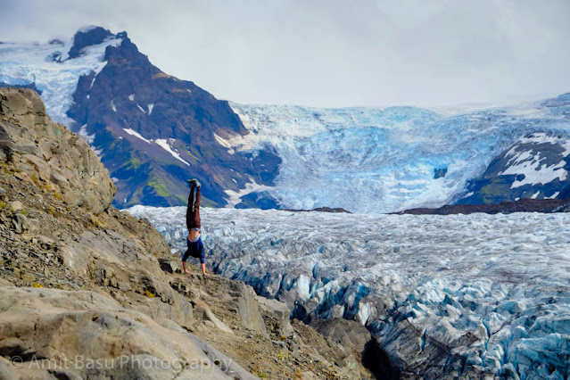
Past Trollskyrkja, you reach an intersection of trail. All of a sudden, the view opens up, and you are face to face with a large ice cap that covers the Katla volcano, and you can see the Mýrdalsjökull glacier. This is where you can start turning back, in a loop, to where you came from. But not before one of the most interesting vista points on the trail. This vista point takes you right on top of the Krossa river. To the left you see the Katla icecap, to the right the Eyjafjallajökull icecap. This is perhaps the most rewarding view of the entire trip. It is made more exhilarating in knowing that, at the vista point, you are standing on a place, the underside of which has been mostly eroded away.


It was time to leave for we had to catch the bus, or risk being stranded in Thorsmork for the night. Gigerly we made our way down the trail which ran quite precipitously along the hillside at places.
There were little caves in a lot of places. One wondered whether Iceland was indeed filled with "huldufolk" (hidden people) that Icelandic folklore talks about at length. Thorsmork appeared to be a great place for the huldufolk to be hiding, after all. We did not meet any in our travels, but, in Thorsmork, you could sense that they were all around, looking at us from the caves, and perhaps waiting for us to leave so that they can get on with their hidden ways.


The bus did turn up on time. The return journey was even more exciting. As promised, the water level was much higher now than it was in the morning. Rather than crossing at right angles, the bus approached the river from a small angle. As it hit the water, you could hear the crunch crunch of the large rocks under the tires. The bus lurched quite violently side to side. Thankfully the driver took the bus across the river quite skillfully, and we were on dry ground again.
But not for long. The minor streams of the morning have now become big rivers, and the bus had to cross all of them. At one such river, we found a couple of hikers, who had obviously crossed to Thorsmosrk in the morning when the water level was low, stranded in the middle of the river on a small sand bed. They were in their underwear in the cold, in an effort to keep the clothes dry. They had crossed some one third of the way into the river, but found the river too deep and the current too strong beyond that. Our driver took pity on them, and opened the bus door so they could climb up. They thanked the driver profusely after the safe crossing of the river.
The luck was not so good for a driver of a SUV. We found the car stuck in the middle of the river with two persons on it. Our driver did not offer them any help. I guessed they had to wait for some other kind soul to pull them out of water. So, yes, don't try to drive to Thorsmork in your typical rental SUV. You will need to be rescued for sure.


By the time to reached the parking lot, it was almost dark. The sky was getting ready for a downpour, and it did start soon, nearly blinding us on the road. About 150 miles or so in pouring rain, we finally found our resting place for the night, Tjaldsvæðið í Svínafelli. It was hard to find the place in near darkness, around 11pm, but we found it some distance away from the Ring Road by trial and error. Yes, hardly anyone lives in most of Iceland, and the countryside can be quite dark.
It was a day filled with adventure.
 |
| Our route during Day 3 in Iceland: covering Seljalandsfoss, to Thorsmork, and finally to Svinafell. |
Comments